
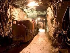

UNESCO Geopark Ore of the Alps
The majority of the UNESCO Geopark Ore of the Alps lies in the greywacke zone, where you can find rock from the Palaeozoic era containing rich ore deposits. The northern border of the geopark belongs to the Northern Limestone Alps and the southern to the Central Alps. However, the geopark not only stands out thanks to its particular geological features, but also due to the prevalence of a prehistoric and historic tradition of mining. The discovery of copper ore, iron and gold in the Bronze Age made this region one of the most important centres for mining in Europe.

UNESCO Geopark Karavanke
The UNESCO Geopark Karavanke is a cross-border Geopark in the border area between Austria and Slovenia. The UNESCO Global Geopark stretches across an area of 1,067 km² and is located between the Petzen and Koschuta Alpine summits, both of which are more than 2,000 metres tall. Rich geological diversity between the Alps and the Dinaric Alps characterises the geopark. The oldest rock formation in the area dates back around 500 million years. The area has a rich tradition of mountain, iron and coal mining.

Styrian Eisenwurzen UNESCO Geopark
The Styrian Eisenwurzen UNESCO Geopark is located in the north of Styria, at the centre of the Northern Limestone Alps and comprises an area of 586 km². It is characterised by its diverse natural and cultural landscape consisting of magnificent forests, broad orchards and charming mountain pastures. Impressive river valleys are surrounded by the peaks of the nearby mountain groups. Hammer mills, charcoal makers and raftsmen were typical of the region in the Eisenwurzen’s heyday of the 15th and 16th centuries, as ore taken from the Styrian Erzberg mine was processed to make high-quality precious objects in the Eisenwurzen.

